By: Rockingham Planning Commission
Getting to the New Hampshire Seacoast is expected to get a lot more difficult in the future according to a team of planners and researchers from Rockingham Planning Commission (RPC), the New Hampshire Coastal Program (NHCP), and the University of New Hampshire (UNH). In response to the threat of significant disruption to the transportation network from future sea-level rise (SLR), the RPC in collaboration with the UNH, the NHCP and the New Hampshire Department of Transportation conducted the vulnerability assessment of the New Hampshire Seacoast transportation corridor. The recently completed Seacoast Transportation Corridor Vulnerability Assessment (STCVA) suggests that 15 of 22 studied roadways to the coast of New Hampshire, as well as multiple locations along on US 1 and NH 1A, could be impassible in the future due to rising sea levels.

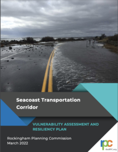
Photo: Kim Reed
The roadway network in coastal New Hampshire can continue to function reasonably well with up to 2.0 feet of sea-level rise but, by 4.0 feet of sea-level rise, connectivity and access are severely disrupted and functionality declines. “The impacts of 4.0 feet of sea-level rise on the transportation network are expected to be extensive” according to Dave Walker, Assistant Director and Transportation Program Manager at the Rockingham Planning Commission (RPC). Road closures resulting from 4.0 feet of sea-level rise will disrupt 108,000 trips per day according the STCVA.
 The STCVA report identifies New Hampshire Seacoast roadways that are subject to greatest flood risk from sea-level rise. The study evaluated changes in traffic and travel patterns resulting from road closures under various sea-level rise scenarios. Ten priority sites were identified for development of adaption options based on impacts to roadway operation, public health and safety, and socioeconomics. The priority sites were further evaluated using the New Hampshire Coastal Flood Risk Guidance which considered project goal, type, location, and timeframe, tolerance for flood risk and relative sea-level rise. Various adaption options were considered for the ten priority sites, including taking no action, avoiding impacts altogether by prioritizing investment in low-risk areas, accommodating, or finding ways to live with the water, resisting or keeping the water out, and relocating or moving out of harm’s way. Some of the adaption options considered include implementing detours, upgrading culverts and bridges, raising the roadway, installing berms and flood walls, or abandoning the roadway.
The STCVA report also provides two case studies at the priority impacted locations of Marsh Road and Parsons in Rye, and US Route 1 at the crossing of the Hampton Seabrook Estuary. These case studies, led by UNH researchers Jo Sias and Jennifer Jacobs, consider roadway construction, and evaluate the timing of different adaptation options by considering the site in the context of the nearby road networks. “The Marsh Road and Parsons Road site provides an opportunity to evaluate the timing of different adaptation options by considering the site in the context of the nearby road network” according to UNH researcher Jennifer Jacobs. “In contrast, the US Route 1 at the crossing of the Hampton Seabrook Estuary analysis will include adaptation options such as bridges and culverts.” said Jacobs. The STCVA report states that these two sites were also selected because the analysis process and the options evaluated at both sites are anticipated to be transferable to other sites in coastal New Hampshire.
Webinar Recording: STCVA and Findings (3/31/2022)
An important outcome of the study is “to improve transportation planning decision making processes by establishing a long-term adaptation framework to incorporate coastal hazards,” says Tim Roache Executive Director of the RPC. The study provides a list of priority sites and a timeline to further investigate and refine adaptation options for the impacted locations and ultimately implement the adaption measures. These results provide an important first step for state regional and local partners to work collaboratively towards identifying and understanding the consequences of SLR in coastal New Hampshire. It is also an initial effort to understand the systemic impacts to travel in the region under higher sea-level conditions.
Looking ahead, planners will use the STCVA project as an opportunity to take advantage of incoming infrastructure funding to further evaluate and refine the conceptual adaptation options identified for each of the priority sites, and ultimately design/construct improvements. In addition, researchers will continue to monitor the latest climate science and SLR projections to better understand risk and probability of inundation to aid in refining a timeframe for adaption measures. In the short term, the RPC staff in collaboration with State and local partners will collaborate to integrate findings and potential transportation projects into the regional transportation planning process with the goal of being prepared for future that may bring daily flooding to our road network.
The STCVA was funded, in part, by NOAA’s office for Coastal Management under the Coastal Zone Management Act in conjunction with the New Hampshire Department of Environmental Services Coastal Program. For more information and to view the report, visit the RPC website.