Photo: Emily Lord
 By: Lisa Wise, NH Sea Grant Extension
Conservation commissions are municipal volunteer boards, charged with promoting “the proper utilization and protection of the natural resources” in communities (NH RSA 36-A). This can include doing assessments of natural resources (e.g., natural resources inventories); developing conservation plans; working to conserve, monitor, and manage conservation lands for various benefits such as wildlife habitat and recreation; reviewing permit applications for natural resource impacts; and encouraging public education about the local natural resources.
In coastal NH, many planning board members and municipal staff have been engaged in climate adaptation projects, such as vulnerability assessments and planning initiatives. However, conservation commissions have typically not been as involved in these efforts. CAW members Amanda Stone (UNH Extension) and Lisa Wise (NH Sea Grant Extension) have recently been meeting with coastal conservation commissions to share climate-related information that is specifically relevant for land and water quality protection.
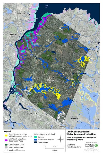
In 2016, The Nature Conservancy released the Land Conservation Priorities for the Protection of Coastal Water Resources: A Supplement to The Land Conservation Plan for New Hampshire’s Coastal Watersheds (2006). The 2016 data cover the coastal watershed and identify areas that provide one or more of the following benefits:
- Flood storage
- Salt marsh migration opportunities
- Water quality protection
- Public water supply protection
These benefits are important to begin with, but even more so in the context of climate change, which is causing rising sea levels, increased extreme precipitation, and potential drought impacts due to rising temperatures.
This outreach to conservation commissions began in 2017 with the NH Setting SAIL Project, where Stone and Wise brought information from the NH Coastal Risk and Hazards Commission Report to coastal conservation commissions and discussed actions they could take to incorporate climate impacts on natural resources in their work. The effort continued into the more recent phase focused on the 2016 data from The Nature Conservancy. Stone and Wise brought community-specific maps of the data plus this simple handout describing the available data to meetings with 11 conservation commissions in the coastal watershed.
# of communities engaged
# of participants in meetings
# of communities that have taken action
Summary of Actions To Date
Municipality |
Completed Actions |
Actions in Progress |
|---|---|---|
| Barrington | Updated conservation lands data on GRANIT | Incorporating WRU data into conservation criteria and co-occurrence map, natural resources assessment storymap, and internal mapping tool (working with Strafford Regional Planning Commission); under final review as of July 2019 |
| Dover |
Accessed WRU data shapefiles for use in project review Developed revised conservation criteria (incorporating WRU data), adopted by OLC on June 20, 2019 |
|
| Exeter |
Shared WRU maps with the Planning Board and loaned the printed versions out several times Have used WRU maps in project review and consideration of wetland mitigation proposals |
Working on an outreach program re: climate and natural resources, building off of the WRU information |
| Greenland | Shared habitat brochures and maps at the transfer station | Keeping track of what other seacoast towns are doing to take action on climate change. |
| Hampton | Outlining a plan to develop an NRI that incorporates climate change and the WRU data | |
| Hampton Falls | Incorporated WRU data in QGIS tool to evaluate conservation value of potential projects | Working on NRI update (and accompanying storymap), incorporating the WRU data |
| North Hampton |
Shared WRU maps with Select Board, Planning Board, and Town Administrator Featured one of the WRU maps in the Community Newsletter, directing readers to the Town website to view all 3 maps |
Updating conservation easement database Working with Rockingham Planning Commission to update 1993 NRI (and natural resources master plan chapter as well) Working with UNHCE/NHSG to present the WRU maps to other municipal boards/committees and community members |
| Rye |
Shared data with Town Planner who plans to use the data in parcel reviews Shared data with the Rye Planning Board and others Town Planner asked town’s GIS staff to put the maps on the Town of Rye’s GIS |
Working with UNHCE/NHSG to develop a plan for updating their NRI (and incorporating WRU data) Working with UNHCE/NHSG to present the WRU maps to other municipal boards/committees and community members |
This project was funded by the Coastal Zone Management Act, 16 U.S.C. 1451-1466, administered by the Office for Coastal Management, National Oceanic and Atmospheric Administration, in conjunction with the NHDES Coastal Program.
Questions? Contact Lisa Wise, Lisa.Wise@unh.edu, 603-862-2356.