Photo: Trevor Mattera
By: Trevor Mattera, Piscataqua Region Estuaries Partnership
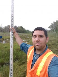
On a cloudy Monday morning in July, I pulled on a reflective (yet, quite fashionable!) vest, and joined Tyler Spillane from the NH Department of Environmental Services (NHDES) out in the field for some tidal crossing assessments as part of the Resilient Tidal Crossing project. Our mission that day was to assess two tidal crossings – one in Hampton and another in Durham – adding the data we collected on the crossings’ conditions and compatibility to a database of similar crossings throughout the coastal region of the state.
What is a tidal crossing?
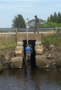
Photo: Trevor Mattera
A tidal crossing is a culvert or bridge that conveys the two-way ebb and flow of the tides. There are many tidal crossings in New Hampshire that are well designed, providing reliable avenues for human traffic, while allowing for adequate tidal flow of water into the marshes and rivers beyond. However, there are also a number of crossings in the area that are in need of repair, likely vulnerable to future sea-level rise, or inadvertently restricting tidal flow. Such crossings could pose potential risks to public safety or have adverse environmental impacts on fish passage or upstream salt marshes.
Through the use of New Hampshire’s Tidal Crossing Assessment Protocol – a standardized method developed through a partnership between The Nature Conservancy and the NHDES Coastal Program, as well as through strong stakeholder engagement – NHDES staff and volunteers are able to evaluate crossing on a number of criteria, such as structural, ecological, and climate resiliency. Tidal crossings can then be prioritized for future infrastructure replacement and habitat restoration projects.
Back in the field…
At our two sites, we used a laser level, surveying staff, and tape measure to take measurements in and around the tidal crossings. Distances and elevations were taken from the road and adjacent salt marsh and stream. We measured and inspected the culverts – and in one case, I scrambled through one in an effort to avoid tramping through the poison ivy. And we examined the substrate and surrounding vegetation. At some points the work could be quite physical and wet, but it was always very interesting and enjoyable. My foot might get stuck in the mud or the water might overtop my boots, but then again, I was outside doing fascinating work that could benefit New Hampshire’s coastal communities and ecosystems. And as I always say: a day in the field beats a day in the office!
Who is supporting this and who is involved?
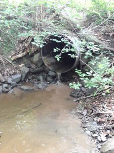
Photo: Trevor Mattera
The Resilient Tidal Crossing project is funded through NOAA’s CZM Projects of Special Merit, which aims to support the development of innovative projects through their coastal management programs. This funding allowed for the assessment of all 120 tidal crossings in NH’s coastal zone, as well as for the hiring of two NHDES field staff for the project. The NHDES Coastal Program is working with the University of New Hampshire and The Nature Conservancy for their data management and analysis needs. Additionally, they have partnered with the UNH Technology Transfer Center (T2) to develop a file geodatabase and web mapping service to enable electronic field data collection directly to the Statewide Asset Database Exchange (SADES); New Hampshire’s primary transportation asset management software, as well as UNH GRANIT, New Hampshire’s geospatial data clearinghouse, to support publishing tidal crossing results on the New Hampshire Coastal Viewer.
NHDES and its partners have also used this project as an opportunity to engage local and regional stakeholders, encouraging those interested to come out in the field and see the new protocol in use. Along with the Piscataqua Region Estuaries Partnership, they have had volunteers from organizations including the NH Geological Survey, NH Department of Transportation, and the Long Island, New York chapter of The Nature Conservancy join them. Additionally, there are plans to have groups out from both Massachusetts and Maine.
Once field work is completed, GIS analyses will be performed, and each tidal crossing site will be assigned various scores based on assessment criteria. These scores will be the basis for a ranked and prioritized list of sites, allowing municipalities, NHDOT, road managers, and natural resource professionals to advance replacement projects based on shared priorities. The final report for the Resilient Tidal Crossing project, as well as collected tidal crossing data, is expected to be available in the spring of 2019. For more information, please contact the NHDES Coastal Program (coastal@des.nh.gov).